Kendal (formerly Kirkby Kendal)
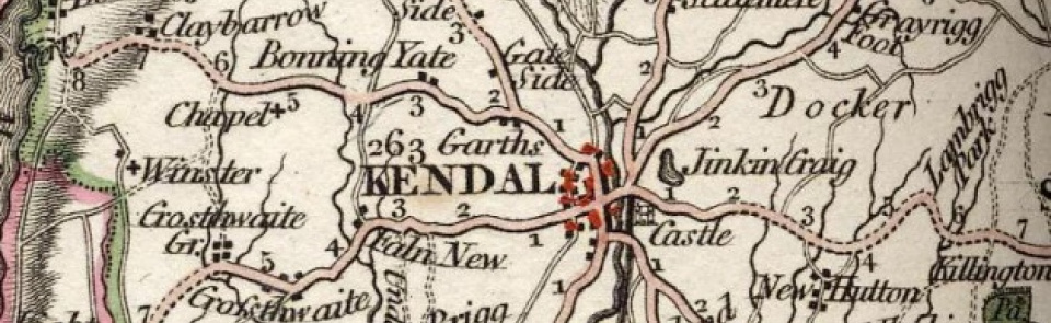
Borough, market and manufacturing town in Kendal ward, Westmorland. This entry covers medieval borough of Kendal and townships of Kirkland and Nether Graveship.
Acreage:
Kendal CP (which included Kirkland) contained 2,242 acres [907 ha] in later 19th century; Nether Graveship CP covered 358 acres [145 ha]. Kirkland and Nether Graveship CPs were absorbed into Kendal in 1908 and municipal boundary was further extended by transfer of 78 acres [32 ha] from Scalthwaiterigg in 1919 and 1,005 acres [407 ha] from surrounding CPs in 1935. As well as built-up area, Kendal CP included open land in large medieval park attached to Kendal Castle on east of River Kent and common land (158 acres [64 ha]) on Kendal Fell, to west of town, enclosed 1767.
Landownership:
Kendal was seat of barony of Kendal, covering much of southern Westmorland. Granted to William de Lancaster c.1150, it descended to William III de Lancaster (d. 1246) and was divided between his nephews, Peter de Brus (d. 1272) and Walter de Lindsay (d. 1271). Lindsay share later became known as Richmond fee; Brus share was divided again, on death of Peter de Brus, between his sisters Margaret, wife of Robert de Ros, and Lucy, wife of Marmaduke de Thweng. Ros share became known as Marquis fee; Thweng share as Lumley fee. Richmond fee descended through Lindsay family, passing by marriage of Christian de Lindsay to Ingelram de Guisnes (d. 1324) and through their descendants to Philippa (d. 1411), wife of Robert de Vere, earl of Oxford. On her death it reverted to Crown, and was subsequently leased until granted by Charles II to Queen Catherine of Braganza; then leased to Lowther family 1694, who purchased it 1810. Marquis fee passed by marriage of Elizabeth de Ros (d. 1395) to Sir William Parr and descended in Parr family to William Parr, marquis of Northampton (d. 1571), brother of Queen Katherine Parr. It then passed to Crown and descended with Richmond fee. Lumley fee descended in Lumley family until exchanged for other lands with Henry VIII 1531-2. Lands in the fee were purchased piecemeal by Bellingham family in mid-16th century and Lumley fee descended thereafter with manor of Levens (q.v.).
Origins and growth of the town:
Medieval Kendal
Presence of Roman fort of ALAVANA at Watercrook, pre-10th century religious site at Kendal (suggested by place-name element Kirkby, ‘church settlement’) and pre-Conquest estate centre just north of town at ‘Strickland’ (recorded in Domesday Book) all suggest that vicinity of later town had become focal point for surrounding area long before foundation of borough. Gilbert fitz Roger fitz Reinfred acquired market charter for Kendal 1189; this, and borough charter granted to inhabitants by Gilbert’s son, William de Lancaster III, in first half of 13th century, probably confirmed an existing trading centre. Borough, focused on market place at junction of route from north over Stramongate Bridge and main route up Kent valley, grew up north of church and close to seats of baronial power, the Norman motte and bailey castle (now Castle Howe) and its 13th-century successor, Kendal Castle, to east of river. Medieval town served as market, religious and administrative centre for whole of barony, though influence of barons of Kendal would have been weakened by partition of barony after 1246. References to fulling mill 1274 and dyeworks 1310 suggest woollen textile industry well established by 1300.
Kendal c.1500-1820
By 1500 Kendal’s textile trade had national market, its coarse woollen cloth known as ‘Kendal green’ being fabric worn by the common man. Kendal was finishing centre for cloth manufactured across rural southern Cumbria, its ‘shearman-dyers’ dominating trade. Town was incorporated by charter 1576 (confirmed and amplified by further charters 1636 and 1684), its government being vested in mayor and 12 aldermen. By 1600 population had probably risen to 2,200-2,600. It suffered during mortality crises of 1590s and 1623; by end of 17th century it had not fully recovered: in 1695 borough (excluding Kirkland) had 2,159 inhabitants. After slump in textile trade in early 17th century, Kendal specialised and diversified: Sir Daniel Fleming, writing 1671, reported that Kendalians ‘seem to be shaped out for trade; improving themselves not only in their old manufacture of cottons, but of late in the makeing of Druggets, Serges, Hats, worsted-stockings &c, whereby many poor are dayly set on work and the town much enriched’. Thomas Denton, writing 1688, said: ‘The people are generally all tradesmen, very industrious & provident, which by the help of their cloathing & cotten trade (which they disperse all over England) makes them much richer then their neighbours. They are a sober, orderly sort of people, and it’s a corporation as regularly govern’d as any, where ever I came; being constituted by the name of maior, aldermen & comminalty. Their revenue is but small, but well managed.’ Cloth industry dominated: tenter grounds (with frames on which to stretch finished cloth) spread out onto surrounding open ground, on Fellside and Gooseholme. Town’s motto, Pannus mihi panis (‘cloth is my bread’) had been coined by early 17th century. Other industries in 18th-century Kendal included making of wool cards; tanning and leather working; snuff making (from 1792); and manufacture of horn combs (established 1794). Population grew rapidly, particularly from the 1730s: by 1801 it had reached c.8,000 (borough containing c.7,000 inhabitants and Kirkland a further 1,000). Its growing importance as regional centre was reflected in newspaper publishing: short-lived titles, The Kendal Weekly Courant and Kendal Weekly Mercury had appeared in 1730s; by 1820 it boasted two papers, the Westmorland Advertiser and Kendal Chronicle (founded 1811; replaced 1834 by the Kendal Mercury) and The Westmorland Gazette (founded 1818).
Kendal since c.1820
Kendal’s manufacturing base was boosted by Lancaster canal, which reached it 1819 (closed 1944) and Lancaster & Carlisle railway, which opened 1846, with spur through Kendal to Windermere opening 1847. Town gained a significant industrial base across the 19th century, not only in textiles but also in iron founding and shoemaking:
Textiles: introduction of steam power from 1843 accompanied an increase in scale of woollen industry. Dockray Hall Mill (or Gandy Mill) operated as woollen mill from 1788; diversified into carpet-making from c.1830; ceased to make woollen cloth after First World War; demolished 1940. Castle Mills (woollen), on site of medieval corn mill, later fulling mill; then carding and spinning mills. Rebuilt 1806 and further expanded 1855 for power loom weaving by J. J. and W. Wilson; closed 1933. Low Mills, rebuilt as woollen fustian mill 1806. Carpet making, established 1822, became an important specialism, first at Dockray mills, then at Castle Mills, where it continued into late 20th century. Hosiery knitting established by E. W. Thompson & Sons 1878 at Sandes Avenue and Bridge Mills, Stramongate (‘the sock mill’); closed 1980s.
Iron foundries developed after canal and railway allowed coal and iron to be transported cheaply. Foundry established at Low Mills c.1840. Canal Iron Works (on site of former warehouses at Canal Head, redundant after arrival of railway) began as agricultural implement manufacturer 1853; developed turbine-making; sold to Gilkes 1887. Isaac Braithwaite & Son established laundry machine engineering works (Ibis Works) on Shap Road by 1927.
Shoemaking grew out of long-established leather trade: in 1829 there were 7 tanners and c. 30 shoemakers. Somervell Brothers, who established leather business in Kendal from 1842, started shoe manufacture from 1860s, registering trade mark ‘K Shoes’ 1875. By 1900 it was a major employer, producing 170,000 pairs of shoes annually. Survived until 1990s.
Other specialist industries included snuff manufacture, established outside town at Meal Bank 1792 (see Scalthwaiterigg). Three main firms of snuff manufacturers in Kendal by later 19th century: Samuel Gawith; Gawith & Hoggarth and Illingworths; the first two merged 2015; Illingworths closed 1983. Limestone quarrying, lime-burning and polishing stone into ‘marble’, took place on Kendal Fell from c.1800.
Kendal’s population more than trebled across 19th and 20th centuries. Total number of inhabitants (Kirkland and Nether Graveship included) grew from c.8,000 in 1801 to 14,183 by 1901. Economic base was transformed across 20th century, with loss of both textile industry and shoemaking. Some manufacturing remained on new industrial estates to north of town (such as Farley’s milk food works, established at Mintsfeet in 1970s). Service industries and administration provided employment, notably Provincial Insurance Company, based in Kendal from 1919. As manufacturing industries declined, Kendal evolved across second half of 20th century into administrative, cultural and tourist centre, its position on edge of Lake District attracting significant retired population. As well as being seat of Westmorland County Council (1889-1974), it continued to serve important local government function after 1974, containing offices of South Lakeland District Council and Lake District National Park Authority and several departments of Cumbria County Council. Population grew rapidly in second half of 20th century, rising from 18,541 in 1951 to 27,505 in 2001.
Places of worship:
Medieval parish church of Holy Trinity, almost certainly pre-Viking foundation, remained mother church to much of south Westmorland, its parish covering 25 townships. Other places of worship in medieval Kendal included Allhallows chapel on Fellside, St Anne’s chapel at Dockray Hall and St Leonard’s hospital. St George’s church (Anglican) in Market Place, built 1755; demolished 1855. As population expanded, new Anglican district churches were established: St Thomas’, Stricklandgate, built 1835-7, and new church of St George, Castle Street, built 1838-41. Mission church, Allhallows chapel, on Fellside, built 1864-6. Town’s cemetery opened 1855.
Kendal had strong and influential nonconformist element. Quaker presence by 1656, when land on Sepulchre Lane was bought for burial ground. Quaker meeting house, Stramongate, built 1688; replaced by present building 1816. Presbyterian chapel in corner of Market Place built by 1702; present Market Place chapel built 1720. Market Place congregation became Unitarian and Orthodox Presbyterian seceders built chapel on Beast Banks 1763, which was sold 1811 (‘Scotch’ burial ground there remained in use until 1855). Subsequent splintering resulted in building of Independent chapel in Lowther Street 1782 (closed 1929), from which further secession 1823 led to building of another Independent chapel in former theatre in Woolpack Yard. Much of that congregation, in turn, left to build Zion chapel (now United Reformed church), in yard off Highgate, 1844; rebuilt 1896. Remainder of Woolpack Yard congregation moved to new chapel, St John’s Church, Sandes Avenue, 1897; demolished in 1980s. Inghamite chapel, in barn on edge of High Beast Banks, established c.1756; rebuilt 1844; converted to housing 1985.
First Methodist church was established in former playhouse (later Working Men’s Institute) in Market Place 1787 and remained there until purpose-built chapel was built at head of Stricklandgate 1828; rebuilt 1882. Wesleyan chapel in Chapel Lane built 1872. Primitive Methodists had built chapel in Castle Street 1823 and moved to new chapel 1870. Job Pennington Memorial Primitive Methodist Mission Hall built on Low Fellside 1899. Sandylands Methodist Cornerstone church built on Sandylands housing estate 1937. Roman Catholic church, rebuilt 1793, was replaced by church of Holy Trinity & St George, New Road, built 1835-7. Evangelical mission hall, Gillingate, built by Quakers 1894; transferred to Methodists 1939; later used by Salvation Army. Other denominations included Christian Brethren, who had chapel near Stramongate in later 19th century; Salvation Army, who had citadel behind Highgate in mid-20th century; Jehovah’s Witnesses, who used former Oddfellows’ Hall as Kingdom Hall; Evangelical church, Parr Street, built 1970; and New Life Community Church, which took over Shakespeare Centre 1994.
Schools:
Free Grammar School founded 1525; rebuilt on Aynam Road, 1889. Bluecoat school, part of Sandes Hospital charity, established c.1670; closed and amalgamated with Grammar School in 1880s. Friends School, Stramongate, first established 1698; moved to larger premises 1792; closed 1932. Expansion of elementary education during 19th century saw National schools at top of Allhallows Lane (founded 1818; girls’ school opened 1824 and infant school 1874; became Central Primary CE School; closed 1985); at St Thomas’ church (1842); at St George’s church (1854) and in Kirkland (girls’ school, 1861). British schools founded in Castle Street (1835) and Kendal Green (1873). Roman Catholic community served by St Mary’s & St Joseph’s schools, New Road, in former Catholic church building. In 1885, as well as these schools, there were 10 private academies. New RC primary school, Dean Gibson School, Gillingate, built 1898. In 20th century new county primary schools were established at Stramongate and at Ghyllside. Secondary education expanded with opening of Kendal High School for Girls 1890; closed 1980 when it merged with boys’ Grammar School. Stramongate Boys’ School opened 1937. Post-war growth of secondary schooling saw new secondary modern schools at Longlands (opened 1959 and 1960) and St Mary’s RC, Hawesmead Avenue (opened 1971; site taken over by Dean Gibson RC Primary School 1977). Re-organisation 1983 resulted in two comprehensive schools, for northern and southern areas of town respectively: at Longlands (now Queen Katharine School) and former Grammar School site (now Kirkbie Kendal School). Vocational education provided by James Allen Technical Institute, Beezon Road, built 1912, forerunner of Kendal Technical College (now Kendal College), Milnthorpe Road, built 1971.
Other institutions:
New Biggin, in middle of Highgate, contained ‘shops’ built c.1500; demolished 1803. Market house built 1855 (used as public library from 1891; demolished 1909); replaced by new Market Hall, opened 1889. White Hall, built as cloth exchange, rebuilt as assembly rooms 1824-5. Moot Hall in Stricklandgate, replaced by Town Hall, converted 1858-9 from former Whitehall assembly rooms. House of Correction (Kendal’s town prison) built at northern end of town, probably pre-1700, to replace dungeon under Moot Hall. Rebuilt 1785; became county gaol after closure of gaol at Appleby 1888; closed as civilian prison 1894; site sold for redevelopment 1907. On establishment of Westmorland County Council 1889, Kendal (rather than ancient county town of Appleby) became seat of county government; County Hall was built 1937-9.
Poor house on Fellside built in 17th century and another for township of Kirkland, probably c.1740. From 1725-1768 Kendal’s workhouse was at Brownsword House, Stricklandgate. Income received by corporation from enclosure of Kendal Fell 1767 used to build new workhouse, opposite House of Correction. This subsequently became Kendal Poor Law Union Workhouse from 1836; workhouse buildings used as Kendal Green Hospital for elderly from 1948 to 1970. Almshouses: Sandes Hospital built 1659; endowed for 8 poor widows 1670. Dowker’s Hospital, endowed 1831; cottage almshouses built in Highgate 1833; demolished c.1960. Sleddal Jubilee Almshouses, Aynam Road, endowed by John Sleddal 1887. Howard Orphan Home for girls, at Stonecross, opened 1865; later used as local authority old people’s home; closed 1990. Cropper Memorial Hospital, Captain French Lane, built 1869-70, became Westmorland County Hospital; closed 1991 when new Westmorland General Hospital opened on Burton Road. Helme Chase maternity home closed 1993. Public bath house, Allhallows Lane, 1863, with swimming baths added 1883.
‘Economic Library’ founded 1797; merged with Mechanics’ Institute (established 1824). Oddfellows’ Hall, Highgate (now converted to housing), established 1833 on site of Unicorn Inn and taken over by Mechanics’ Institute 1857. Working Men’s Reading Association opened Workmen’s Newsroom in Market Place 1843. Christian and Literary Institute, Kent Street, (similar in objectives to Mechanics’ Institute) established 1852. Museum established by William Todhunter 1796 taken over 1835 by Kendal Literary and Scientific Society (founded 1817), which established museum and library in Stricklandgate House, which they leased 1854. Museum moved to new premises (formerly wool warehouse) adjacent to Allen Technical Institute in 1918; now Kendal Borough Museum. Abbot Hall Art Gallery opened 1962, with adjacent Museum of Lakeland Life and Industry. Subscription library, founded 1794, taken over by Kendal Literary and Scientific Society; earliest public library was that opened in Workmen’s Newsroom 1847. Free public library established in former Market Hall 1891 and replaced by Carnegie Library, Stricklandgate, opened 1909. Playhouse (in what later became Working Men’s Institute, Market Place) founded 1758; moved c.1780 to The Fold, Stricklandgate. Purpose-built theatre in Woolpack Yard, known as New Theatre until 1807 and Theatre Royal thereafter; taken over by Independent chapel 1823. Further theatres built in Old Shambles 1828 and behind Shakespeare Inn 1829; latter closed under pressure from nonconformists 1834; subsequently used as ballroom (latterly known as Shakespeare Centre). St George’s Hall, Stramongate, built 1878, used for theatrical productions and as cinema in early 20th century, becoming bingo hall in 1960s; demolished 1993. ‘Roxy’ cinema opened 1913 (closed 1950s); Palladium, Sandes Avenue, opened 1931 (closed 1989). New theatre built 1993

