Atterpile Castle Background Grange over Sands
Atterpile Castle, now known as Castle Head, near Grange, may have been an Iron Age promontory fort. A large number of artefacts including Roman and Northumbrian coins have been found there.
The Castle Head Field Centre now occupies the country retreat built by the iron master John Wilkinson in 1778. He was buried in the garden there in 1808, although later he was reinterred in the church. The house stands on a conical hill on flat land near Lindale, which one time had been an island in an arm of the sea, later occupied by the mosses of the Winster. The island appears to have at one time been known as Atterpile, a name which may be related to attercop, a dialect word for a spider – while the ‘pile’ ending may be the same as in Piel Island, meaning a fortification.
When work was being carried out for Wilkinson, a large number of ancient objects were found, described thus by Edwin Waugh, writing in 1860 (Over Sands to the Lakes, Ireland & Co, Manchester, 1860, p.11)
‘About sixty years ago [in fact much earlier, c.1765] many curious articles were found there, among which were parts of a human skull, vertebrae etc, teeth of buffaloes, tusks of boar, pieces of limestone resembling hen’s eggs [could these have been sling-stones?]; rings of blue rag-stone, lead, clay and glass; ninety-five sticas of Northumbrian kings [other sources say just five], seventy-five Roman coins [one of which was of Constantine], a stone supposed to have been a mould for casting silver rings; iron ore, petrified bone, pebbles, impressions of clay, pottery or bone, and other ancient relics’. Stockdale (Annals of Cartmel, Ulverston, 1872, p.204) also mentions flints, ‘jaws of a large kind of deer’, and ‘coins, supposedly British’.
Clearly this collection, sold in 1808 and now lost, dates from several different periods, possibly going back into the prehistoric. It is unlikely to have been ‘a Roman settlement’ as Waugh surmised but may well have been occupied both in the Iron Age, and in the post-Roman period: although possibly Stockdale went too far in claiming it had been ‘successively a stronghold of the Ancient Britons, Romans, Saxons, Danes and Norwegians’ The site is naturally defended by steep slopes on all sides, and there may well have been an Iron-Age promontory fort there, although any trace of it will have been lost under Wilkinson’s works.
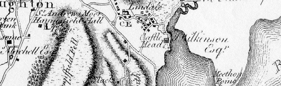
The map is Yate’s map of Lancashire (1786), and locates Castle Head (and its owner J Wilkinson Esq) at the mouth of the Winster. The whole of the land between there and Meathop has since been reclaimed from the sea.
Posted by Bill Shannon

